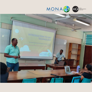
On Wednesday, April 17, 2024 a team from the Mona GeoInformatics Institute (MGI) engaged with students at the Geography and Geology Department at The University of the West Indies, Mona Campus on the use of drones and its applications in modern GIS. MGI’s team was led by Technical Projects Coordinator Mr. Darren Fletcher and Research Officer Mr. Romario Anderson. Thank you to Dr. Robert Kinlocke from the Department of Geography and Geology, UWI Mona for giving us the opportunity to share this information with his GIS students.

The MGI team provided critical information to the Geographic Information System (GIS) students at the department within the Faculty of Science and Technology. Key areas that were covered in the presentation included:
- Understanding drone techniques to assist with data collection
- The basics of drone technology
- Applications of drones in environmental monitoring
- Drone Capabilities & Functionalities
- Types of drone flights along with the required applications to utilize
- Understanding No-Fly Zones

It is critical for the modern geographer or general geospatial expert to incorporate drones in the work that they do for several reasons. Some key areas of drone application include: Urban planning, Disaster management, Precision agriculture, Photography and general mapping. The incorporation of drones into your workflow can be cost-effective, it provides access to areas that would be otherwise difficult to access and improves flexibility in data collection techniques.

Overall, drones have become a powerful tool for geographers and geospatial scientists. Their ability to collect high-resolution data quickly and efficiently is transforming the way we study the Earth and its landscapes. As drone technology continues to develop, we can expect even more innovative applications to emerge in the future. MGI has emerged as one of the leaders in the use and application of drone technology in the Caribbean region.
MGI continues to work with The University of the West Indies to build capacity in this area.
MGI provides drone training to the wider public. Sign up here: https://main.monagis.com/gis-training if you are interested.
Email: info@monainformatixltd.com
Phone: (876) 977-3160-2
WhatsApp: (876) 388-9097


